ATA > Korean Tradition > The Constancy of Spatial Structure > Location and Development
ˇˇ
Location and Development of the Settlement
| Home l Info l News l Reading l E-mail l Search l Korean | |
|
ATA > Korean Tradition > The Constancy of Spatial Structure > Location and Development | |
|
ˇˇ Location and Development of the Settlement |
|
|
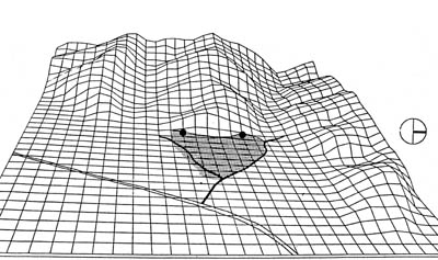
The site for the settlement is seriously selected in Korea. Besides practical conditions such as obtaining enough water and nearby farmland, one of the important criteria for site selection is the matter of Fengshui. Fengshui, often translated into Geomancy, is a theory interpreting surrounding natural environment, ultimately to find the adequate place for dwelling. Its physical aspects may be described with the notions of 'enclosure' and 'axis'. The ideal site of Fengshui is embodied as the model of 'rear mountain, front water' with the settlement as center. In the model, the settlement is defined with mountains in its rear, and with water in its front. The slope gently runs from high rear to low front, along with the waterway. The sides of the site are also moderately defined with hills which are not so high as the rear mountain. Accordingly, typical Korean villages are located on the topography of 'high in rear, low in front'. Given that they are located on the ideal site of Fengshui, they are framed into the linear organization with adequate enclosure by mountains and water. In this way, the location of the settlement underlies the unique structure of the settlement which is general and constant in Korea.
 Fig 1. The typical section of the settlement site in Korea 1.rear mountain: It is the key of the enclosure. It usually
offers woods for fuel and the site for tombs, and has a mentally high
hierarchy.
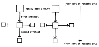
Here the typical development process of the settlement is to be reviewed. A man and his family with servant families move into a village which may be a undeveloped, newly selected site or an already occupied one by other families than by his clan. He settles down naturally at the best spot of the site which is often found at the foot of the important moderate mountain peak, that is, at the interface of mountains and flatland (Fig 2). He is called 'Village Entered Ancestor' by the offspring dwelling there from that time on. Ideally, his house is handed over to the eldest son, and then to the eldest grandson, and so on, over periods, and it is called 'Family Head's house'. In case that a few, not only one, clans dwell at a settlement, there are as many Family Heads' houses. The settlement gets set up through continuous offshoots of the family by gradually transforming the land in front of the Family Head's house into house lots.
The settlement develops as more households need their houses. So,
vegetable plots scattered in the housing site gradually turn into house
lots to a certain extent, till
the housing site is filled with house lots. It is asserted that the
topographic location and social character of the settlement affect its
development pattern greatly. Therefore the concrete development pattern
comes to be unique in each settlement. However, it is possible to define
the typical development pattern in the clan village
which is argued in detail at the next section of the paper. The pattern
is
presented in Fig 3 as a model. It explains how the housing site
of a clan village develops as offshoot from the Family Head's house
proceeds. And it
shows the general process of lot formation in the typical clan village,
located on the typical site of 'front of a mountain, rear of
water'.
There are practical contributors to the settlement development; the chief carpenter and the geomancer. The chief carpenter who leads a construction team plays an important role in the selection of the house type and the construction process. Generally, most houses of a settlement are built by him. The role of the geomancer and the clan organization should be considered important in analyzing the spatial structure of the settlement, too. In general, residents follow the geomancer's advice even though they may have practical disadvantages by following it7. Usually, the geomancer dwells for a long time at the village, so he is well acquainted with local ecology, and his advice is often rational in practical aspects as well as in symbolic ones enough to make the residents be persuaded. In that the constructional activities of a settlement are guided by the work pattern of these contributors through their lifetimes, the identity of the settlement space may be partly ascribed to them.
7. For example, some houses of Yeondong village in the Korean southern area have their main gates and Inner buildings facing north or northeast, not a favorable prospect. They say it the immediate reason why the Inner building came to face north unlike those of other houses in the village that the geomancer who was consulted by them, seeing the geographical features of surrounding mountain, recommended the prospect. Considering all of such houses are located at the periphery of the housing site, however, they probably regarded the fact important that the visual connection with farmland and the open vista are obtained by facing farmland which is at the north of the houses, in spite of other disadvantages. (Han, Pilwon, op. cit., p.135) * The titles of Korean references have been translated into English by the author. ˇˇ |